Patrick Basso
September 2, 2014 6:39 am
Five Things that Went Wrong Backpacking The CT's Collegiate West Route
Overview
August 15, 2014 - August 18, 2014
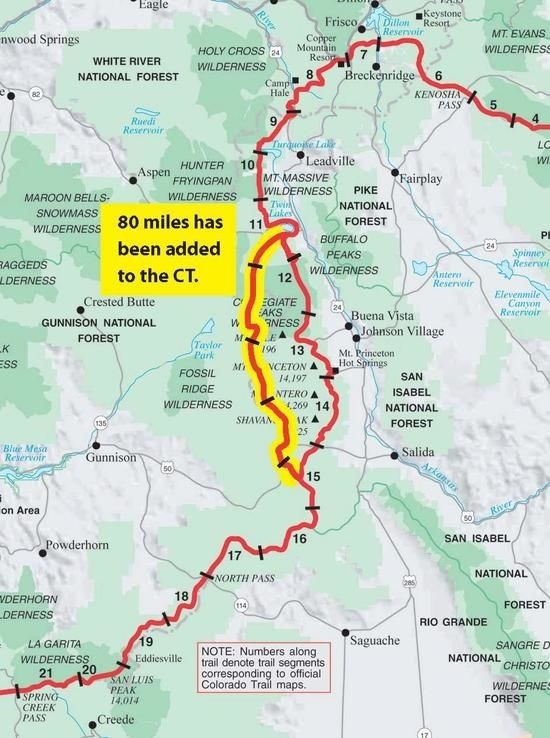
Colorado Trail Collegiate West Route
Duration: 3.5 Days Total Elevation Gain: 18,478 Total Milage: 80 Miles Trail Info: http://www.coloradotrail.org/collegiate-west.html Maps and Guides: http://www.shop.coloradotrail.org/2014-CT-Collegiate-Loop-Package-CLBNDL.htm
Challenges and Lessons Learned
#1 - Modified Zelph Starlyte Alcohol Stove Would Not Ignite via Mini Bic or Matches
CHALLENGE:
- The Zelph Starlyte stove would not light after adding alcohol
- Result: no morning coffee or Mountain House eggs and bacon breakfast.
ASSUMPTION:
- Cold temperature outside led to a cold stove & fuel. I assume the cold temperatures did not allow the fuel to vaporize. This stove requires the alcohol to vaporize into a gas in order to light it.
SOLUTION:
- Prime Zelph Stove: After adding fuel to the alcohol stove, I put a small amount of alcohol on the titanium floor pan and ignited the fuel on the floor. This priming fuel ignited easily. Once the stove increased in temperature the fuel inside the stove began to vaporize and then ignited. Woo Hoo - I now had a hot meal for dinner and for the remainder of the trip.
#2 - Mini Bic Lighter Would Not Ignite or Spark to Produce a Flame
CHALLENGE:
- The mini bic lighter got wet because of a mistake on my part.
ASSUMPTION:
- I have a small yellow 4 inch by 4 inch towel that I use to clean and dry out my pot when I am done with each meal. I decided to try to put the small towel inside the pot for storage. This is also where I put the mini bic lighter and Trail Designs wind screen. I assume the wet towel led to a wet bic lighter that would not spark.
SOLUTION:
Attempted Solution:
- Tried to blow out moisture and get lighter to ignite - No Success
First Solution:
- Used backup matches - success #1
Second Solution:
- Put mini bic in shirt pocket for the day and allowed it time to dry out and by dinner the mini bic started working again.
- Note to self: Do not put wet cleaning towel inside the pot.
#3 - Frogg Togg Ultralite 2 Pants Failure - Crotch Seam Split Open
CHALLENGE:
- Took a big step to climb a boulder and to my surprise the Frogg Togg Ultralite pants split right down the crotch seam.
ASSUMPTION:
- Garment critical weakness is the triple stitched crotch seam acting like pre-scored perforations on paper - - rip!
SOLUTION:
First Solution
- Used Duct tape on the inside and outside of crotch seam over the split.
- The Duct tape reinforcement held perfectly for the remainder of the hike.
- Duct tape sticks very well to Frogg Toggs.
- Note I cannot remove the duct tape or it will pull the polypropylene material apart. Duct tape is now a permanent patch.
Second Solution (found after trip was completed)
Wöhali Non-Woven Pants from Bass Pro Shop
- Same non-woven polypropylene tri-layer pants as Frogg Togg but with reinforced seams
- Wöhali Pants 7.5 oz vs Frogg Togg Pants 4.5 oz A few cool features for a little more weight.
Features
- Seam sealed
- Two front pockets
- Adjustable elastic hook-n-loop waist
- Hook-n-look adjustable leg cuffs
- Snap secured leg openings
#4 Bronchitis - Chest Infection
CHALLENGE:
- After day one I started to experience a constant cough and by day 2, I was coughing up green phlegm - say hello to Bronchitis
ASSUMPTION:
- I was seated behind an individual who was showing signs of a cold on the plane just prior to the hiking trip.
SOLUTION:
- Pull out map and look for exit point along the trail in case anything starts to get worse. By the time the green phlegm appeared I was stuck in the middle of segment 3 and started looked at the map for possible exit points more seriously. I noticed that beginning of segment 4 crosses Tin Cup Pass Road and I guessed it was about 15 to 22 miles away from Mt. Princeton Hot Springs via dirt road #267. I also noted that I had 35 miles to Monarch Pass, which would be the end point for my hike. I also noticed there were a few more exit points along the way. By the time I hit Tin Cup Pass Road I was starting to feel a little better so I decided to push on towards Monarch Pass. I decided to push on since the cough was not debilitating, I still had energy, I did not have a fever and my symptoms were improving — the phlegm changed from green to yellow, then milky white and finally to clear (sorry for the gross details). All good signs that my body was working hard to fix the internal problem.
#5 Inability to use Cell Phone until Beginning of Segment 5
CHALLENGE:
- I knew ahead of time that cell phone service was going to be bad if not impossible.
ASSUMPTION:
- No or very poor cell phone coverage along the Collegiate West route of the Colorado Trail
SOLUTION:
- I carry a couple of cards with Kathi’s contact information and a blank back for notes. I would try and use day hikers to pass along information to Kathi. - - This system worked when I met a small group of 3 people and had them call Kathi to give her a status update and change the meeting place for the end of the trip to top of Monarch Pass instead of Highway 50 CT east route. I will close the loop later.
Conclusion:
- Trip Duration: 3.5 days — averaged 23 miles per day with a chest cold
Trip Distance: 80 Miles
I have been pondering what type of fun I had on this trip with Bronchitis, I am not sure if this was type 2 or type 3 fun - either way I am glad I was able to complete the Collegiate West Route.
Favorite aspect of The Collegiate West High Route and an Important Warning:
Segment 3 is by far the Most Beautiful and Exhilarating High Route of the Colorado Trail
2014 New 15.9 mile reroute is single track between Cottonwood Pass and Tin Cup Pass Road with four steep climbs and great views.
Good News: The 2014 CT Collegiate Loop Map Book and Latitude 40, Salida/Buena Vista Trails map both shows the new route and can be trusted with a little orienteering experience. I say this because there is no clear signage on this new route and a few intersecting routes at the beginning.
	WARNING: The signage for the beginning of Segment 3 at Cottonwood Pass is confusing.  In the Cottonwood Pass parking area there is a large trailhead sign on the west side of Cottonwood Pass Road with both CT and CDT badges - see image below. It may help to note that you will be staying on the high ridge here behind the sign moving towards the high point directly in front of you.  Just below the top of the high point you will cut left following the trail via the ridge line heading in a southernly direction.

	WARNING: The 2014 Data Book DOES NOT depict the new segment 3 high route and as such I got confused between the difference in my maps and the data book (The data book details the original lower altitude route)  Please use either the 2014 CT Collegiate Loop Map Book or Latitude 40, Salida/Buena Vista Trails map for details.
Cottonwood Pass Trailhead Sign
